Services
Tree Survey
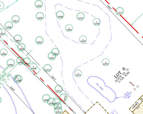
A tree survey is typically conducted in connection with design and/or construction purposes. The survey typically locates all trees 8” in diamter and larger and identifies their species. Many cities, such as Austin, have tree ordinances which protect certain species of trees which can affect the design and layout of improvements on a property. The trees are tagged with a numbered tag which allows engineers, architects and inspectors to readily identify the trees in the field. The survey allows engineers and architects to design improvements in relation to the trees on the property. The survey data is usually incorporated into their plans and allows the design of drainage, retention areas and utilities serving the project and the ability to determine which trees may need to be removed from the site. The survey is provided to the client in an Adobe pdf format and also in an AutoCad drawing format containing all of the survey points, trees and the line work of the improvements. Contact Delta Land Surveying and we will send you an Adobe pdf Authorization Form defining the scope of work to be completed and the cost. You can then complete form, sign and email back to get the project started.
DELTA LAND SURVEYING
© Delta Land Surveying - All Rights Reserved.
Texas Firm No. 10194017 - Oklahoma Firm No. 5405


Services
Tree Survey
A tree survey is typically conducted in connection with design and/or construction purposes. The survey typically locates all trees 8” in diamter and larger and identifies their species. Many cities, such as Austin, have tree ordinances which protect certain species of trees which can affect the design and layout of improvements on a property. The trees are tagged with a numbered tag which allows engineers, architects and inspectors to readily identify the trees in the field. The survey allows engineers and architects to design improvements in relation to the trees on the property. The survey data is usually incorporated into their plans and allows the design of drainage, retention areas and utilities serving the project and the ability to determine which trees may need to be removed from the site. The survey is provided to the client in an Adobe pdf format and also in an AutoCad drawing format containing all of the survey points, trees and the line work of the improvements. Contact Delta Land Surveying and we will send you an Adobe pdf Authorization Form defining the scope of work to be completed and the cost. You can then complete form, sign and email back to get the project started.
DELTA LAND SURVEYING
© Delta Land Surveying - All Rights Reserved.
Texas Firm No. 10194017 - Oklahoma Firm No. 5405