A. L. T. A. / N. S. P. S. Land Title Survey
The American Land Title Association (ALTA) and the National Society of Professional Surveyors (NSPS) jointly created criteria for land title surveys commonly known as an “ALTA/NSPS Land Title Survey” for use in connection with title insurance purposes. The criteria established is in the form of “Minimum Standard Detail Requirements for ALTA/NSPS Land Title Surveys” which are typically updated every five years. The standards define the how the field work is completed and what must be contained within the survey plat. Additionally, clients may specify on Table “A” exactly which elements they would like to have reflected on the survey.Table “A” items can include specific information such as building heights, zoning information, number and types of parking spaces, delineation of wetlands and any off-site easements. Contact Delta Land Surveying and we will send you an Adobe pdf form of Table “A” which you can complete defining the scope of work for the required survey. We will then provide you with an estimate of the cost to meet the scope of work for your specific project.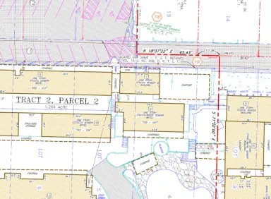
Category 1A Land Title Survey
The Texas Society of Professional Surveyors (TSPS) established criteria for land title surveys commonly known as an “Category 1A Land Title Survey” for use in connection with title insurance purposes. A Category 1A Land Title Survey is usually conducted in connection with residential properties as opposed to an ALTA/NSPS Land Title Survey which is typically conducted on commercial properties. Contact Delta Land Surveying and we will send you an Adobe pdf Authorization Form defining the scope of work to be completed and the cost. You can then complete the form, sign and email back to get the project scheduled.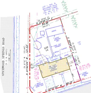
Boundary Survey
A boundary survey will locate the property corners and typically any improvements within five feet of the property lines. A survey plat is provided, in an Adobe pdf format, which depicts the corner monuments found or set, the relationship of the property with the adjoining properties and the aforementioned improvements. The survey is usually conducted in connection with construction such as a fence or simply so potential buyers can physically see the location of the property on the ground. Contact Delta Land Surveying and we will send you an Adobe pdf Authorization Form defining the scope of work to be completed and the cost. You can then complete the form, sign and email back to get the project scheduled.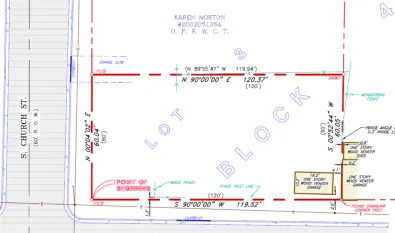
Topographic Survey
A topographic survey is typically conducted in connection with design and/or construction purposes. The survey determines the topography of a site and usually shows contour elevations at a one foot interval to NAVD88 datum (North American Vertical Datum of 1988). The survey allows engineers and architects to design improvements in relation to the elevation of the property. The survey data is usually incorporated into their plans and allows the design of drainage, retention areas and utilities serving the project. The survey is provided to the client in an Adobe pdf format and also in an AutoCad drawing format containing all of the survey points, contours and the line work of the improvements. Contact Delta Land Surveying and we will send you an Adobe pdf Authorization Form defining the scope of work to be completed and the cost. You can then complete the form, sign and email back to get the project scheduled.
Tree Survey
A tree survey is typically conducted in connection with design and/or construction purposes. The survey typically locates all trees 8” in diamter and larger and identifies their species. Many cities, such as Austin, have tree ordinances which protect certain species of trees which can affect the design and layout of improvements on a property. The trees are tagged with a numbered tag which allows engineers, architects and inspectors to readily identify the trees in the field. The survey allows engineers and architects to design improvements in relation to the trees on the property. The survey data is usually incorporated into their plans and allows the design of drainage, retention areas and utilities serving the project and the ability to determine which trees may need to be removed from the site. The survey is provided to the client in an Adobe pdf format and also in an AutoCad drawing format containing all of the survey points, trees and the line work of the improvements. Contact Delta Land Surveying and we will send you an Adobe pdf Authorization Form defining the scope of work to be completed and the cost. You can then complete the form, sign and email back to get the project scheduled.
Easement Survey
An easement survey is typically conducted to create an easement across a property in order to grant to an individual or other entity the legal right to use a portion of someone else’s property for a specific purpose. The easement may be surface, sub-surface or overhead in nature. The survey is typically conducted in connection with the preparation of the legal document prepared by an attorney which will legally create the easement and be filed for record in the Official Public Records of the county in which the easement lies. Typical types of easements are access easements, utility easements and reciprocal joint use easements. The survey is provided to the client in an Adobe pdf format and generally consists of an exhibit depicting the easement along with a metes and bounds description of the easement which are then incorporated into the legal document by the attorney. The complete recorded document provides notice to all parties, their assigns, and the public of the easement and the rights associated with the easement. Contact Delta Land Surveying and we will send you an Adobe pdf Authorization Form defining the scope of work to be completed and the cost. You can then complete the form, sign and email back to get the project scheduled.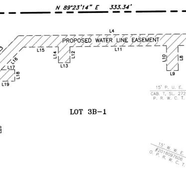
Form Survey
A form survey is typically conducted as part of the construction permitting process when constructing a home or building. Typically the surveyor is contracted to stake the location of the building to be constructed. The contractor will then construct wood forms in preparation for pouring the concrete foundation. The surveyor will then return and verify that the form boards are in the correct location and provide a “Form Survey” which will be presented to the government entity before permission is granted to actually pour the foundation. The survey is provided to the client in an Adobe pdf format and generally consists of an exhibit depicting the location of the form boards in relation to the boundary line and/or easements. Contact Delta Land Surveying and we will send you an Adobe pdf Authorization Form defining the scope of work to be completed and the cost. You can then complete the form, sign and email back to get the project scheduled.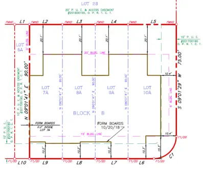
Delta Land Surveying - All rights reserved.
Texas Firm Number: 10194017 | Oklahoma Firm Number: 5405
Delta Land Surveying

Delta Land Surveying - All rights reserved.
TX Firm #10194017 | OK Firm #5405
A. L. T. A. / N. S. P. S. Land Title Survey
The American Land Title Association (ALTA) and the National Society of Professional Surveyors (NSPS) jointly created criteria for land title surveys commonly known as an “ALTA/NSPS Land Title Survey” for use in connection with title insurance purposes. The criteria established is in the form of “Minimum Standard Detail Requirements for ALTA/NSPS Land Title Surveys” which are typically updated every five years. The standards define the how the field work is completed and what must be contained within the survey plat. Additionally, clients may specify on Table “A” exactly which elements they would like to have reflected on the survey. Table “A” items can include specific information such as building heights, zoning information, number and types of parking spaces, delineation of wetlands and any off-site easements. Contact Delta Land Surveying and we will send you an Adobe pdf form of Table “A” which you can complete defining the scope of work for the required survey. We will then provide you with an estimate of the cost to meet the scope of work for your specific project.Category 1A Land Title Survey
The Texas Society of Professional Surveyors (TSPS) established criteria for land title surveys commonly known as an “Category 1A Land Title Survey” for use in connection with title insurance purposes. A Category 1A Land Title Survey is usually conducted in connection with residential properties as opposed to an ALTA/NSPS Land Title Survey which is typically conducted on commercial properties. Contact Delta Land Surveying and we will send you an Adobe pdf Authorization Form defining the scope of work to be completed and the cost. You can then complete the form, sign and email back to get the project scheduled.Boundary Survey
A boundary survey will locate the property corners and typically any improvements within five feet of the property lines. A survey plat is provided, in an Adobe pdf format, which depicts the corner monuments found or set, the relationship of the property with the adjoining properties and the aforementioned improvements. The survey is usually conducted in connection with construction such as a fence or simply so potential buyers can physically see the location of the property on the ground. Contact Delta Land Surveying and we will send you an Adobe pdf Authorization Form defining the scope of work to be completed and the cost. You can then complete the form, sign and email back to get the project scheduled.Topographic Survey
A topographic survey is typically conducted in connection with design and/or construction purposes. The survey determines the topography of a site and usually shows contour elevations at a one foot interval to NAVD88 datum (North American Vertical Datum of 1988). The survey allows engineers and architects to design improvements in relation to the elevation of the property. The survey data is usually incorporated into their plans and allows the design of drainage, retention areas and utilities serving the project. The survey is provided to the client in an Adobe pdf format and also in an AutoCad drawing format containing all of the survey points, contours and the line work of the improvements for use in the design process. Contact Delta Land Surveying and we will send you an Adobe pdf Authorization Form defining the scope of work to be completed and the cost. You can then complete the form, sign and email back to get the project scheduled.Tree Survey
A tree survey is typically conducted in connection with design and/or construction purposes. The survey typically locates all trees 8” in diamter and larger and identifies their species. Many cities, such as Austin, have tree ordinances which protect certain species of trees which can affect the design and layout of improvements on a property. The trees are tagged with a numbered tag which allows engineers, architects and inspectors to readily identify the trees in the field. The survey allows engineers and architects to design improvements in relation to the trees on the property. The survey data is usually incorporated into their plans and allows the design of drainage, retention areas and utilities serving the project and the ability to determine which trees may need to be removed from the site. The survey is provided to the client in an Adobe pdf format and also in an AutoCad drawing format containing all of the survey points, trees and the line work of the improvements for use in the design process. Contact Delta Land Surveying and we will send you an Adobe pdf Authorization Form defining the scope of work to be completed and the cost. You can then complete the form, sign and email back to get the project scheduled.Easement Survey
An easement survey is typically conducted to create an easement across a property in order to grant to an individual or other entity the legal right to use a portion of someone else’s property for a specific purpose. The easement may be surface, sub-surface or overhead in nature. The survey is typically conducted in connection with the preparation of the legal document prepared by an attorney which will legally create the easement and be filed for record in the Official Public Records of the county in which the easement lies. Typical types of easements are access easements, utility easements and reciprocal joint use easements. The survey is provided to the client in an Adobe pdf format and generally consists of an exhibit depicting the easement along with a metes and bounds description of the easement which are then incorporated into the legal document by the attorney. The complete recorded document provides notice to all parties, their assigns, and the public of the easement and the rights associated with the easement. Contact Delta Land Surveying and we will send you an Adobe pdf Authorization Form defining the scope of work to be completed and the cost. You can then complete the form, sign and email back to get the project scheduled.Form Survey
A form survey is typically conducted as part of the construction permitting process when constructing a home or building. Typically the surveyor is contracted to stake the location of the building to be constructed. The contractor will then construct wood forms in preparation for pouring the concrete foundation. The surveyor will then return and verify that the form boards are in the correct location and provide a “Form Survey” which will be presented to the government entity before permission is granted to actually pour the foundation. The survey is provided to the client in an Adobe pdf format and generally consists of an exhibit depicting the location of the form boards in relation to the boundary line and/or easements. Contact Delta Land Surveying and we will send you an Adobe pdf Authorization Form defining the scope of work to be completed and the cost. You can then complete the form, sign and email back to get the project scheduled.
Delta Land Surveying


